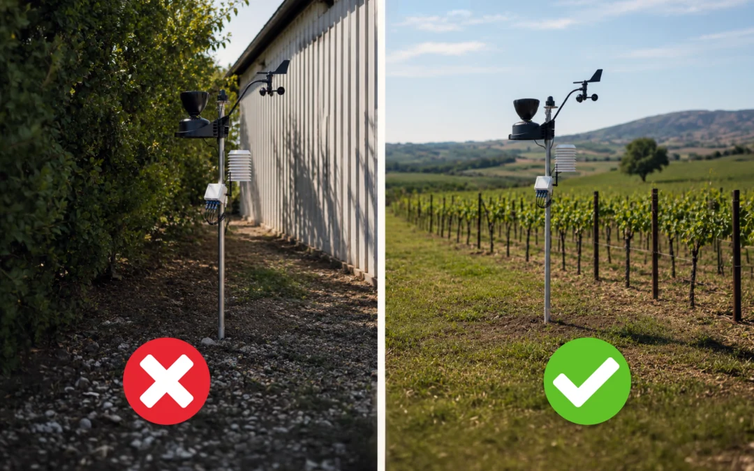
A poorly located station doesn’t provide bad data. It provides good data from a location that isn’t your plot.
And that’s the problem: the values seem reasonable, no one suspects anything, and decisions about irrigation or treatment are based on a reality that doesn’t exist.
After hundreds of installations in vineyards, orchards, and almond groves, these are the five mistakes we’ve had to correct most often in the field.
1. Too close to an obstacle
A hedge, a building, a row of poplars, or even a thick pole can alter the microclimate around them much more than it seems. They block the wind, cast shade at certain times of the day, and, at night, radiate the heat they have accumulated.
The rule of thumb: leave a minimum distance of ten times the height of the obstacle. A 3-meter hedge requires a 30-meter separation. If that’s not possible, at least place it on the side that doesn’t cast a shadow during the middle of the day.
This effect manifests itself in three ways simultaneously: an underestimated wind speed, a biased temperature, and, as a result, an ETo that cannot be used to calculate irrigation.
2. Makeshift sensor heights
Each sensor has its own standardized height, and this is not just a bureaucratic whim: agronomic models are calibrated based on those heights.
- Temperature and relative humidity: between 1.5 and 2 m above the ground, always inside the radiation shield.
- Anemometer: at 2 m if the data is to be used to calculate reference evapotranspiration.
- Rain gauge: with the opening perfectly horizontal and high enough to avoid splashes from the ground, but not exposed to turbulence.
- Foliar wetness: at the height of the crop’s sensitive zone (grape cluster in a vineyard), tilted at an angle of about 30–45° so that water runs off as it would on an actual leaf.
- Pyranometer: facing south and free of obstacles that cast shadows on the sensor; poor placement can reduce the measured radiation and, as a result, lead to an underestimation of ETo.
A poorly oriented weather station or a rain gauge tilted at a 5° angle introduces systematic errors that no algorithm can correct later.
3. Install it on a surface other than the one where the crop is growing
It’s the quietest mistake. The station ends up being set up on gravel, next to a compacted dirt road or at the edge of a concrete slab, because that’s the spot with the easiest access.
These surfaces heat up much more than soil covered with vegetation, raising the recorded temperature, reducing relative humidity, and completely skewing dew formation. The result: disease models that underestimate the risk precisely on the nights that matter most.
The correct approach: a floor with the same vegetation cover as that which predominates on the plot, maintained with low but present vegetation.
4. Choose a comfortable spot over a prestigious one
The head of the plot, next to the irrigation shed, at the corner facing the road. All of them make sense logistically, but none of them make sense agronomically.
The right question isn’t “Where do I get the best results?” but “Which management area do I want this data to represent?”
If the plot has a valley where cold air accumulates, a monitoring station at the highest point will never detect the frost that is actually damaging crops below. If there are two soil types with different water-holding characteristics, a single monitoring station will make a decision based on both—and will be wrong about one of them.
In that case, the solution is not to move the station: it is to supplement it with sensors distributed at critical points.
5. Forgetting that the plot changes
A location that is appropriate in Year 1 may no longer be so in Year 5.
The young vineyard is growing; the windbreak hedge planted next to it is already four meters tall; a hail-protection net is being installed; a new shed is going up to the south…
Added to this is the basic maintenance that’s most often overlooked: tall grass under the station, a rain gauge funnel with traces of pesticide or a nest, a solar panel covered in dust, a guardhouse with cobwebs inside.
A visual inspection every spring, before the season begins, prevents most surprises.
Before deciding on the location, check
- Distance to obstacles ≥ 10 × their height
- Area beneath the station equivalent to that of the crop
- Standardized heights and correctly oriented observation post
- Location representative of the management area, not the access route
- Secure mounting and consideration of the surrounding area’s growth over the next 5 years
- Network coverage and solar panel orientation verified on-site
A well-located station goes unnoticed. Simply put, for years, its data matches what you see in the field. And when that happens, you can start making decisions based on that data.
At Cesens, we assess each site before installation: topography, management zones, and data objectives.
If you’re not sure whether your station is in the right place, please contact us.